Answering the need for reliable, truck-friendly routing, these GPS devices are designed to help long-haul drivers avoid low bridges, limit hazards, and find secure loading docks. The top picks below are best for fleets and solo drivers who require tailored routes based on truck size, weight, and preferred rest stops. The list also highlights each device’s strengths for different truck profiles, from owner-operators to fleet drivers.
| Product | Best For | Why It Stands Out |
|---|---|---|
| Garmin dezl OTR720 (Renewed) | Large-truck fleets and daily long hauls | 7-inch display, custom truck routing, high-resolution BirdsEye imagery |
| Garmin dēzl OTR620 | Mid-size trucks and regional hauls | 6-inch display, consistent routing based on truck specs, loading dock data |
| Garmin Dezl OTR620 (Original) | Professional drivers seeking clarity | 6-inch touchscreen, commercial routing, community-driven insights |
| Garmin dezl OTR820 | Large vehicles with dual-display needs | 8-inch screen, robust routing and satellite imagery |
| Rand McNally RANDTAB7 | Drivers valuing industry-specific routing | Custom trucking routes, comprehensive POIs and safety alerts |
Garmin dezl OTR720, 7-Inch Truck GPS Navigator
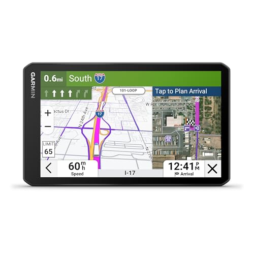
The dezl OTR720 targets professional truckers who need a larger in-cab display and custom routing that accounts for truck size and weight. Its 7-inch touchscreen offers bright, high-resolution visuals for easy navigation. It provides alerts for bridge heights and sharp curves, helping drivers plan safer routes. BirdsEye Direct Satellite Imagery gives overhead views of destinations to aid approach and loading. Best for fleets and solo drivers on longer routes where loading-dock access and parking data matter most. A caution: some routing features may be limited by local road restrictions, so always follow posted signs.
Garmin dēzl OTR620, 6-Inch Truck Navigator

The dēzl OTR620 is ideal for mid-size trucks and regional routes, offering custom routing that considers truck dimensions and weight. It also incorporates community-shared loading docks and truck entrances, making site access planning easier. It includes BirdsEye Direct Satellite Imagery for destination previews and provides alerts for upcoming sharp curves. Choose this if you want a compact but capable navigator with strong route customization. Better for drivers who prioritize quick, at-a-glance route decisions and reliable dock guidance. Limited by some regional road restrictions; confirm routes before turning.
Garmin Dezl OTR620 GPS Truck Navigator

This OTR620 variant emphasizes professional-grade navigation with a 6-inch display and custom routing that accounts for truck size and load. It benefits drivers who rely on community insights about parking, loading docks, and truck-friendly stops. Real-time alerts cover curves, grades, and speed changes, while PrePass notifications save time at weigh stations. A potential limitation is that some features rely on regional infrastructure and user-contributed data, so verify dock availability in unfamiliar areas before departure.
Garmin dezl OTR820, 8-Inch Truck Navigator

The OTR820 stands out for drivers who want a larger, easier-to-read display alongside robust routing and satellite imagery. Its 8-inch screen is better for cab visibility, especially on long hauls. It maintains custom routing based on truck size and weight, with early alerts for bridges and curves. It’s well-suited for drivers who value a dual-orientation display and high-contrast navigation. Limitation: bigger screens may consume more windshield space and battery life when used as a portable device.
Rand McNally RANDTAB7 7-Inch GPS Truck Navigator

The Rand TAB7 emphasizes industry-specific routing with Rand Navigation 2.0 and 2026 maps. It allows route customization based on truck dimensions and considers real-time traffic, weather, fuel prices, and speed camera alerts. It’s best for drivers who want an all-in-one navigation system with extensive POIs, including rest stops, parking, and truck services. A caveat: the data network reliance may affect real-time accuracy in remote areas; verify alternate routes if GPS signals are weak.
Buying Guide
What should you ask before buying a truck GPS?
- How big is your truck and what are its height, weight, and load constraints? Look for custom routing features that factor these parameters.
- Do you need satellite imagery and destination previews? BirdsEye Direct or similar imagery helps plan docks and entrances.
- How important are loading docks, parking availability, and weigh-station alerts? Community-driven data can improve decisions on stops.
- Is a larger screen worth trade-offs in cab space or power consumption? An 8-inch display is easier to read on long drives but bulkier.
- Do you operate in regions with limited cellular coverage? Pre-downloaded maps and offline routing enhance reliability.
- Will you benefit from real-time weather and wind speed alerts? This enhances safety on routes with hazardous conditions.
Frequently Asked Questions
- What is the advantage of truck-specific routing? It customizes paths for height, weight, and hazardous materials, reducing the risk of road restrictions.
- Are satellite imagery features worth it for truckers? Yes, they help visualize destination access points like docks and gates before arrival.
- Can these devices replace a paper map? They are tools to supplement route planning but should be used with posted signs and local knowledge.
- Do truck GPS units offer real-time weigh-station alerts? Many do, saving time through bypass and approach notifications.
- Is a larger screen always better? A bigger display improves readability, but consider cab ergonomics and mounting space.
- Do these devices require ongoing subscriptions for maps? Some offer free lifetime map updates while others require periodic updates.