Finding the right GPS for off-road adventures means balancing rugged durability with accurate topographic data, offline maps, and real-time navigation features. The following hand-picked models are designed to handle rough terrain, variable weather, and remote trails while helping you plan routes, avoid hazards, and locate campgrounds or services along the way. Below you’ll find five standout options, each with key strengths for off-road exploration.
Selected products at a glance
| Product | Brand | Key Strengths | Typical Use |
|---|---|---|---|
| Garmin Tread XL Overland Bundle | PlayBetter | 10″ display, off-road maps, altimeter, barometer, compass, BirdsEye imagery | ATV/UTV, overland expeditions |
| Garmin Montana 700 | Garmin | Rugged MIL-STD, glove-friendly, multi-GNSS | Handheld trail navigation |
| Garmin dēzl OTR1010 | Garmin | 10″ truck-focused navigation, Birdseye imagery | Truck and trailer routing |
| Garmin Tread 2 Overland Edition | Wearable4U | 8″ rugged display, satellite imagery, weather, open-source maps | Off-grid expeditions |
| HINYFVOZ 9-Inch Car GPS | HINYFVOZ | HD touchscreen, lifetime map updates, safety alerts | Cars and light-duty towing routes |
Note: The list emphasizes devices with durable builds, offline or satellite imagery options, and navigation features suited for rough terrain. Each model has unique strengths, so choose based on your vehicle type, preferred maps, and whether you need truck-specific routing or off-road trail data.
Garmin Tread XL Overland Bundle

The Garmin Tread XL Overland Bundle is built for extreme terrains, combining a rugged 10-inch touchscreen navigator with preloaded topography and BirdsEye Satellite Imagery for landscapes unseen from standard road maps. It includes a power solution and accessories tailored to off-road use, such as a suction cup mount and magnet-assisted mounting. The device has built-in sensors like altimeter, barometer, compass, and pitch/roll gauges to help you interpret the vehicle’s position on uneven surfaces. Its preloaded data supports overland travels, including iOverlander POIs and campgrounds, ensuring you can find campsites and fuel stops without constant connectivity. In tough conditions, the bundle’s waterproof design and battery flexibility can reduce downtime on long expeditions.
Key features include: rugged, waterproof construction; 10-inch ultrabright display for daylight visibility; built-in topography and satellite imagery; iOverlander and public campground data; and an extra power bank for extended trips. This option is particularly strong for ATV, UTV, or small-craft expeditions where a large display and self-contained power are advantageous. Consider this bundle if you prioritize a large navigation interface and a portable power backup for multi-day trips in remote areas.
Garmin Montana 700

The Montana 700 offers rugged, glove-friendly operation with a 5″ color touchscreen and MIL-STD 810 certification for environmental endurance. Its multi-GNSS compatibility (GPS, GLONASS, Galileo) enhances satellite reception in challenging areas. Preloaded TopoActive maps support road and trail navigation, while outdoor sensors include a 3-axis compass and a barometric altimeter, useful for altitude changes on climbs. The Montana 700’s handheld form factor makes it a flexible choice for hikers, overlanders, or trail runners who want a durable, highly capable device that can be mounted on a vehicle or carried on foot. It is especially advantageous for backcountry routes where detailed terrain data and reliable signal tracking are critical.
Strengths include rugged construction, direct map access, and reliable sensors for outdoor navigation. Potential drawbacks might be a smaller screen compared to dedicated vehicle navigators, but the Montana 700’s portability and robust performance make it a strong companion for off-road exploration on foot or in rough terrain.
Garmin dēzl OTR1010
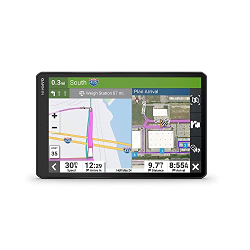
The dēzl OTR1010 is designed for large-vehicle navigation with a 10-inch display that supports landscapes or portraits. It provides custom routing tailored to truck dimensions, with warnings for height restrictions, weight limits, and sharp curves. The device uses high-resolution Birdseye satellite imagery to offer overhead views of loading docks and gate access points, which can simplify yard-to-road transitions and dock side maneuvers. While primarily aimed at truck drivers, its detailed road data and imagery can also benefit off-road enthusiasts who may encounter mixed terrain or need precise route planning near freight corridors or industrial areas during expeditions. Always verify local conditions and posted signage in addition to digital routing.
Key considerations include truck-focused routing accuracy, the availability of Birdseye imagery, and the potential need to adapt to non-truck terrain. If your off-road trips frequently intersect parking lots or industrial access points, the dēzl OTR1010’s data layers can be an asset.
Garmin Tread 2 Overland Edition

The Garmin Tread 2 Overland Edition is an 8-inch all-terrain navigator designed for off-the-grid travel. It features weather-resistant construction (IP67) and a high-contrast touchscreen that remains readable in difficult lighting conditions. The device supports turn-by-turn trail navigation and integrates OpenStreetMap data along with U.S. Forest Service Motor Vehicle Use Maps. The inclusion of subscription-free satellite imagery allows users to download high-resolution overhead views for route planning and terrain assessment. Though it emphasizes off-road use, the flexibility to view satellite imagery offline can help with navigation on remote trails where cell coverage is sparse. Always cross-check with posted signs and local conditions for safe travel on unpaved routes.
Best uses include planning unpaved road trips, exploring forest service roads, and coordinating group rides with compatible map layers. Users should be aware of potential data gaps on certain off-road networks and plan accordingly with supplementary maps or on-site reconnaissance.
HINYFVOZ 9-Inch GPS with Lifetime Updates

The HINYFVOZ 9-inch GPS focuses on large, easy-to-read maps with lifetime North American map updates. It emphasizes clear voice turn-by-turn guidance and safety alerts such as speed limits, red-light camera warnings, and school zone notices. While marketed as a car/truck navigator, its large display and updated maps can benefit drivers who undertake long off-road sections that connect through urban corridors or highway stretches. The device’s broad screen and alerts can complement more rugged, dedicated off-road units by providing quick route validation and driver awareness on mixed-terrain trips. Consider this option if you want a straightforward, high-visibility navigator with robust update guarantees.
As with any GPS intended for off-road use, verify that the device has the necessary topo layers, satellite imagery access, or downloadable maps for your specific trails. Pairing with dedicated off-road maps or trail data can enhance overall reliability.
Buying Guide: Key Purchase Considerations
When selecting an off-road GPS, consider the following factors to match your vehicle, terrain, and travel style.
- Display and visibility: Larger screens are easier to read on the move, especially in bright sun or dusty conditions. Look for high-brightness displays and glove-friendly touchscreens if you ride or hike with gloves.
- Durability and water resistance: MIL-STD ratings and IP ratings indicate ruggedness. For extreme conditions, prioritize waterproof seals and shock tolerance.
- Maps and data: Evaluate whether the device includes topo maps, satellite imagery, and off-road trail networks (BirdsEye, OpenStreetMap, or relevant local data). Preloaded data is helpful, but offline map access is essential for remote trips.
- Navigation features: Off-road navigation benefits from altimeters, compasses, pitch/roll gauges, and trail routing. Vehicle-focused devices should offer truck routing alerts for height, weight, and curve warnings if you plan to drive larger vehicles on mixed surfaces.
- Power and battery life: For long expeditions, battery life and external power options (power banks or vehicle compatibility) extend device uptime without frequent charging.
- Mounting options: Suction cup, magnet mounts, rugged handles, or handheld configurations influence how the unit integrates with your vehicle or backpack.
- Update cadence and support: Lifetime map updates reduce ongoing costs, while subscription-free data can be a practical choice for away-from-home travel.
- Compatibility with other gear: Some units pair with external sensors, wearables, or mobile apps for route sharing and live updates. Consider your ecosystem and workflows.
When evaluating choices, align the device’s core strengths with your typical trips—whether you’re riding rugged trails, crossing unpaved backcountry, or coordinating logistics for overland expeditions. A balanced approach often means selecting a primary off-road navigator with strong terrain data and an auxiliary device for city routing or quick checks in camp.