Explore winter backcountry with rugged, weather-sealed GPS devices built for snowmobiling. This guide highlights five top choices that provide trail maps, topographic data, and off-road navigation tailored for snow trails across the U.S. and Canada. Each option emphasizes glove-friendly displays, durability in extreme cold, and reliable map content to help you ride with confidence.
| Product | Brand | Display | Key Maps | Water/Military Rating |
|---|---|---|---|---|
| Garmin Tread 2, Powersport Navigator | Garmin | 6” glove-friendly | OpenStreetMap, US Forest Service MVUM, Adventure Roads | IP67 |
| Garmin Tread Powersport Off-Road Navigator | Garmin | 5.5” glove-friendly | Topographic North America, MVUM, BirdsEye | IPX7 |
| Garmin zūmo XT | Garmin | 5.5” ultrabright | BirdsEye, on-road/off-road layers | Rain-resistant; rugged |
| Garmin eTrex 22x | Garmin | 2.2” color | Topo Active routable maps | Rugged design |
| Garmin RV 795 | Garmin | 7” touchscreen | RV parks and services, Live traffic | Rugged design (Road-focused) |
Note: The five products above emphasize snowmobile-friendly navigation, durable builds for extreme cold, and comprehensive mapping. All are suitable for trail riding and backcountry exploration across North America, with varying screen sizes and map content to match different preferences and riding styles.
Garmin Tread 2: Powersport Navigator

The Garmin Tread 2 is a 6-inch glove-friendly navigator designed for extreme weather. It delivers turn-by-turn trail navigation with OpenStreetMap data, US Forest Service MVUMs, and Adventure Roads content. High-definition elevation data helps riders plan routes with private and public land details, campgrounds, and snow trails. Built to withstand cold environments with IP67 water rating, this device supports on- and off-road routing, making it suitable for rugged snowmobile trips.
Garmin Tread Powersport Off-Road Navigator

This rugged, IPX7-rated navigator is built for off-road adventures with a 5.5-inch glove-friendly display and ultrabright screen for bright daytime viewing. It ships with preloaded topographic maps of North and Central America, along with street maps and U.S. land boundaries. The device supports U.S. Forest Service roads and trails with MVUM and offers BirdsEye Satellite Imagery for independent map downloads without a subscription. A powered mount ensures stable installation on snowmobiles or other powersport vehicles.
Garmin eTrex 22x: Rugged Handheld GPS

The eTrex 22x offers a compact, rugged handheld option with a 2.2-inch color display and preloaded Topo Active maps featuring routable roads and trails for cycling and hiking. While smaller, its reliable navigation and durable construction make it a valuable backup or primary device for snowmobile trips where size and simplicity matter.
Garmin Tread Powersport Off-Road Navigator with Group Ride
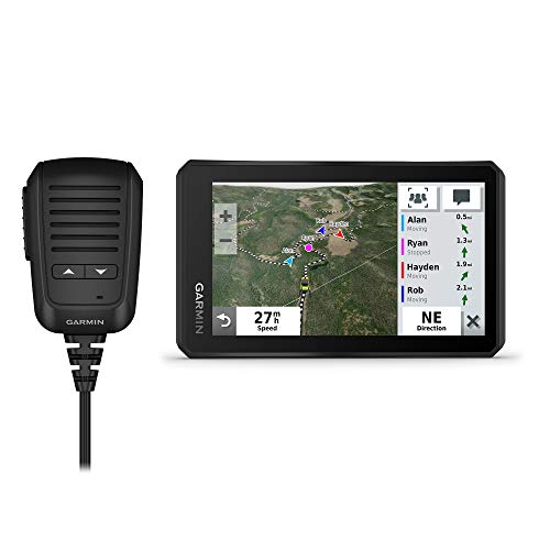
This version adds Group Ride Radio and group tracking for up to 20 riders, enabling push-to-talk communications and live location sharing. It includes preloaded topographic and street maps of North America, public land boundaries, MVUM content, and BirdsEye Satellite Imagery for enhanced off-road view. The 5.5-inch display remains glove-friendly and ultrabright for daytime visibility.
Garmin RV 795: Large 7-Inch RV Navigator

The RV 795 provides a larger 7-inch display with custom routing and live traffic/weather. It includes a preloaded directory of RV parks and services and access to plans from planRV and Foursquare. While marketed for RV use, its large screen and live data can be advantageous for snowmobile trips that require broad situational awareness on winter roads and staging areas.
Buying Guide
Navigation needs for snowmobile trails vary. Consider these key purchase considerations to choose the best GPS for your riding style:
- Display and usability: Glove-friendly touchscreens, screen brightness, and readability in bright snow glare matter most for winter riding.
- Mapping content: Look for topographic detail, public/private land boundaries, MVUM data, and BirdsEye or satellite imagery to improve route planning and situational awareness.
- Durability and weather sealing: IP ratings (IP67/IPX7) and rugged construction ensure reliability in cold, wet, and dusty environments.
- Connectivity and integration: Group ride features, satellite imagery, and hardware mounts can boost safety and collaboration on larger trips.
- Power and mounting: Battery life, powered mounting options, and compatibility with powersport vehicles influence long-day outings on the snow.
- Size and portability: Handheld versus vehicle-mounted units balance portability with map visibility and ease of use.
- Subscription and data: Preloaded maps save time; consider BirdsEye and other imagery options if you prefer offline access without ongoing fees.
- Coverage area: Ensure the device covers U.S., Canada, and key snow trails you plan to ride, with accurate MVUM and land boundaries for your routes.
In evaluating options, consider a primary navigator for trail maps and a secondary handheld device for backup or scouting. For group rides, features like Live Tracking and Group Ride Radio can enhance coordination and safety. Always verify local road and trail restrictions before heading out, and carry additional navigation aids as a backup to digital devices.