Choosing the right GPS for SXS trail riding means balancing rugged durability, reliable off-road maps, trail-specific features, and rider safety tools. The following picks are designed to withstand dust, water, and vibration while delivering turn-by-turn directions, group tracking, and easy mounting options. Use this guide to compare models that excel in trail navigation, backcountry routing, and companion features for group rides in remote areas.
| Product | Brand | Key Strengths | Platform Type |
|---|---|---|---|
| Garmin Tread SxS | Garmin | 8” ultrabright touchscreen, Group Ride Radio, rugged IP67 | Dedicated powersport navigator |
| Garmin Tread 2 – SxS Edition | Garmin | 8” display, faster processor, 10 Hz GPS, open maps | Off-road navigator |
| Garmin Montana 700 | Garmin | Rugged MIL-STD 810, glove-friendly, multi-GNSS | Handheld navigation |
Note: The following sections review five relevant GPS devices that suit SXS trail riding, focusing on durability, navigation features, and rider-focused utilities. Facts are drawn from listed product features and common industry capabilities for off-road navigation devices.
Garmin Tread SxS: Rugged Navigator With Group Ride

The Garmin Tread SxS is a purpose-built powersport navigator built to endure dusty, wet, and rocky environments. It features an 8-inch ultrabright touchscreen that remains usable with gloves, plus a locking magnet-assisted mount and tube mount for secure on-vehicle placement. Its IP67 rating supports dust and water exposure, making it suitable for muddy trails and sudden weather changes. A standout feature is the Group Ride Radio with push-to-talk and group tracking for up to 20 riders, enabling coordinated rides and safety monitoring. Turn-by-turn trail navigation uses adventure roads and trails map content to guide along unpaved routes. Some map limitations apply, and users should always obey posted road signs and local rules while riding.
Key considerations:
– Group tracking requires other Tread navigators and vehicle power for continuous operation.
– OpenStreetMap-derived data provides broad coverage but may not cover every trail with precise precision.
– Rugged design supports long off-road sessions without compromising display readability.
Garmin Tread 2 – SxS Edition

The Garmin Tread 2 – SxS Edition emphasizes rugged durability with an 8″ ultrabright, glove-friendly display and IP67 sealing. A faster processor and 10 Hz GPS deliver responsive navigation even as maps and routes evolve during rides. The kit includes a roll cage mount and bare wire power cable for straightforward SxS integration. Maps pull from OpenStreetMap, U.S. Forest Service, and Adventure Roads and Trails, with turn-by-turn guidance across dirt, snow, and urban settings. High-resolution satellite imagery is accessible directly on-device via built-in Wi‑Fi, enabling riders to scout terrain beforehand.
Key considerations:
– 32GB memory can support detailed map sets; verify local media storage needs.
– Satellite imagery improves terrain awareness but may increase battery usage.
– Visual terrain cues assist in unfamiliar routes and improve confidence on remote sections.
Garmin Montana 700: Rugged Handheld GPS

The Garmin Montana 700 is a rugged handheld with MIL-STD 810 durability and a glove-friendly 5-inch color touchscreen. It supports multi-GNSS (GPS, GLONASS, Galileo) for broader satellite coverage and preloaded TopoActive maps for versatile outdoor navigation. Built-in 3-axis compass and barometric altimeter add expedition-friendly sensors for altitudinal awareness and bearing. Versatile mounting options broaden use across different vehicles and backpacks, making it a flexible option for riders who switch between foot, UTV, and vehicle navigation needs.
Key considerations:
– Handheld form factor favors hikers and out-and-back adventures; ensure mounting compatibility for vehicles.
– MIL-STD 810 rating helps withstand vibration and temperature shifts on rough trails.
– Preloaded topo maps reduce the need for constant data connections in remote areas.
Trail Tech Snow Voyager Pro Kit UTV GPS

The Trail Tech Voyager Pro Kit combines a 4-inch anti-glare display with IP67 rating for tough outdoor use. It provides base maps, topography, hill shading, and trails, plus GPX trail recording and transfer via microSD. Real-time buddy tracking features allow group visibility, distance adjustment, and Buddy Beacon, enabling safer rides without cell service. This option emphasizes rider collaboration and offline data sharing, which can be valuable on secluded trails where cellular coverage is limited.
Key considerations:
– Smaller display compared to 8-inch models; check visibility in bright sun or low light.
– MicroSD support enables offline trail archiving and sharing of routes.
– Buddy tracking offers enhanced group awareness but may require calibration for precise range and latency.
Garmin Montana 700 (Renewed): Rugged GPS Handheld
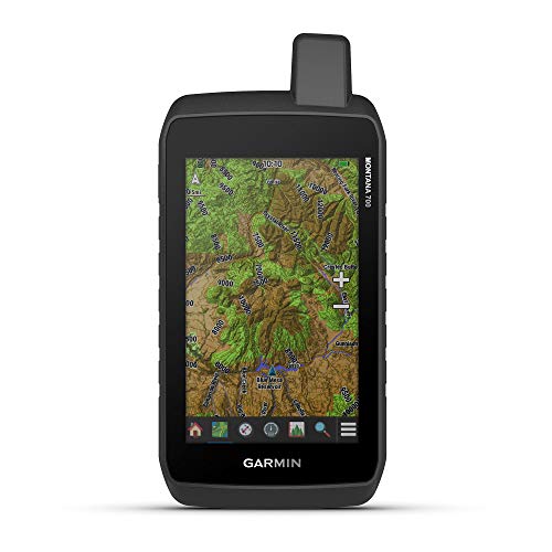
This renewed Garmin Montana 700 retains the rugged build and multi-GNSS capabilities with a glove-friendly 5-inch touchscreen. It supports versatile mounting options and preloaded TopoActive maps for road and trail navigation. With MIL-STD 810 durability, it’s designed to withstand demanding trail conditions, while the compact form factor makes it easy to carry on longer rides or when transitioning between modes of travel.
Key considerations:
– Renewed devices can offer cost savings but verify warranty and battery health.
– Multi-GNSS support enhances satellite connection in challenging conditions.
– Preloaded maps suit riders who prefer immediate navigation without swapping storage cards.
Buying Guide: Key Purchase Considerations for SXS Trail Riding
- Durability and weather resistance: Look for IP ratings (IP67 or better) and MIL-STD or equivalent durability to handle dust, water, vibration, and temperature swings common on off-road trails.
- Display and controls: Bigger, glove-friendly touchscreens ease use on the move. Consider brightness levels for sun glare and readability in varying light.
- Navigation maps and features: Open-source map layers (like OpenStreetMap), official trail data, and topo maps help with off-road planning. Turn-by-turn guidance, trail difficulty indicators, and hazard alerts add practical value on remote routes.
- Connectivity and safety features: Group ride capabilities, buddy tracking, and push-to-talk radios improve safety. Battery life and the ability to operate without cellular service are important for long outings.
- Mounting options and compatibility: Ensure the device can be securely mounted in your SXS or toolbox, with appropriate power connections and vibration resistance.
- Storage and updates: Consider built-in memory versus expandable storage, plus map update frequency and access to fresh data for seasonal trail changes.
- Power and endurance: Check power requirements and availability of vehicle or accessory power to support continuous navigation and communication during trips.